FLOOD: Hydrologic Modeling using OpenFlows - AulaGEO
Loại khoá học: Engineering
Learn to plan, design, model and optimize flood models using OpenFlows - FLOOD
Mô tả
This is a course to learn the use of FLOOD, a software to model and simulate extreme events using accurate and reliable flood risk analysis data
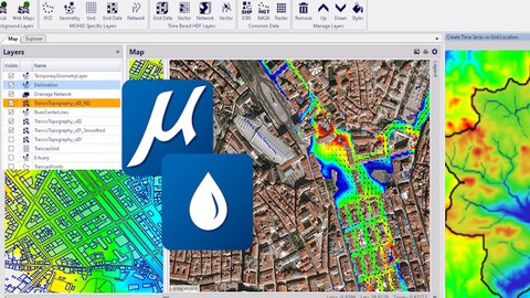
FLOOD is flood modeling software for analyzing and mitigating flood risk in urban, riverine, and coastal areas. Using spatially distributed numerical models, users can quickly simulate all hydrological and hydraulic processes to support emergency planning and green-initiative design. Apply a multi-scale 1D/2D approach to support flood early warning systems (FEWS).
In this course you will learn the use of a software specialized in this features:
Mitigate urban flooding
Urban flooding poses risks to residents, damages property and infrastructure, and disrupts urban services. Create efficient solutions that increase the resilience of urban drainage systems and implement mitigation measures, such as low-impact development and green initiatives. Mitigate these issues by producing detailed simulations to identify bottlenecks and hotspots that hinder the capacity of stormwater drainage systems.
Prevent riverine flooding
Calculate river flow to understand, evaluate, and optimize reservoir operations to minimize and prevent damages from riverine floods. Design and improve emergency structures and outline flood-resilient land use strategies, all within a climate change context. #AuaGEO Simulate the exchange of water between the river flow and (sub)surface flow based on hydraulic gradients. Produce inundation maps, flood risk maps, and hazard maps that address riverine flows, river defense capacity, and large-scale land use changes. Estimate the drainage network from topographic maps and to interpolate cross sections in space.
Model coastal flooding
Coastal flooding can be caused by high tides, storm surges, and tsunamis, sometimes in combination with insufficient urban drainage capacity or high upstream river flows. Dynamically model complex array of processes related to coastal flooding to find accurate solutions for defining and improving storm surge and tsunami protection plans.
Analyze flood inundation areas
Calculate the extent of flooded areas and estimate the flood hazard based on water column heights and peak flow velocities. Easily integrate models generated with OpenFlows SewerGEMS to simulate surface and stormwater flow. Create scenarios and make comparisons among different alternatives to rapidly find the best solution for flood risk mitigation.
Add real-world context, animation, and visualization
Explore and present model results using a wide range of integrated visualization capabilities, including the option to make smooth, continuous animations of the obtained results. Help stakeholders better understand the risks and impacts of flooding events and potential mitigation actions with integrated 3D reality models. Bring simulations to life by generating realistic visualizations of flood events using LumenRT.
Build and manage hydraulic models
Leverage and import many well-known external data formats to maximize ROI on geospatial and engineering data. Jumpstart the model building process and manage models effectively to keep focus on making the best engineering decisions.
#AulaGEO CONTENT
EXISTING WORKSPACE
Lesson 1 Introduction
Lesson 2 Importing an Existing Model
Lesson 3 Navigation through Project Structure
Lesson 4 Visualizing Mapped Data
Lesson 5 Model Simulation
Lesson 6 Visualizing Time Series Output
Lesson 7 1D Model Node or Pipe Files
Lesson 8 Visualizing Mapped Output
NEW WORKSPACE FROM SCRATCH
Lesson 9 Creating New Workspace
Lesson 10 Importing Digital Terrain
Lesson 11 Grid Creation
Lesson 12 Smooth Digital Terrain
Lesson 13 Simulation Setting
Lesson 14 Time Series Data
URBAN FLOW SIMULATION
Lesson 15 Introduction
Lesson 16 Getting Started
Lesson 17 Review Existing Information
Lesson 18 Grid for Digital Terrain
Lesson 19 Delimiting the Study Area
Lesson 20 Defining Grid Data for Surface Roughness Coefficient
Lesson 21 Defining Grid Data for Surface Permeability
Lesson 22 Creating a New Domain
Lesson 23 Importing the Inlets Shapefile into OpenFlows FLOOD
Lesson 24 Setting Time Series Reports for Stormwater Network Elements
WATERSHED SIMULATION
Lesson 25 Importing Existing Workspace
Lesson 26 Review Existing Project
Lesson 27 Rainfall-Runoff Simulation in Watershed
Lesson 28 Topographic Grid Data
Lesson 29 Computational Grid
Lesson 30Terrain Grid and Smooth Grid
Lesson 31 River Burn In
Lesson 32 Remove Depressions
Lesson 33 Domain Association & Water Delineation
Lesson 34 Cross Sections of the Drainage Network
Lesson 35 Configuring New Simulation
Lesson 36 Time Series Data
Lesson 37 Simulation and Results
BENTLEY HYDROLICS AND HYDROLOGY PRODUCTS
Lesson 38 All Products
Bạn sẽ học được gì
Working with existin and from scratch workspaces
Importing data for flood simulation
Model simulation
Urban flow and watershed simulation
Working with GIS data
Yêu cầu
- Civil works is preferible
Nội dung khoá học
Viết Bình Luận
Khoá học liên quan


Đăng ký get khoá học Udemy - Unica - Gitiho giá chỉ 50k!
Get khoá học giá rẻ ngay trước khi bị fix.
Đánh giá của học viên
Bình luận khách hàng